QR page
Office
Welcome to Mowsbury Hillfort
Fragments of Iron Age and Romano-British pottery had been reported from the site since the late 19th century and may also possibly be of prehistoric origin.
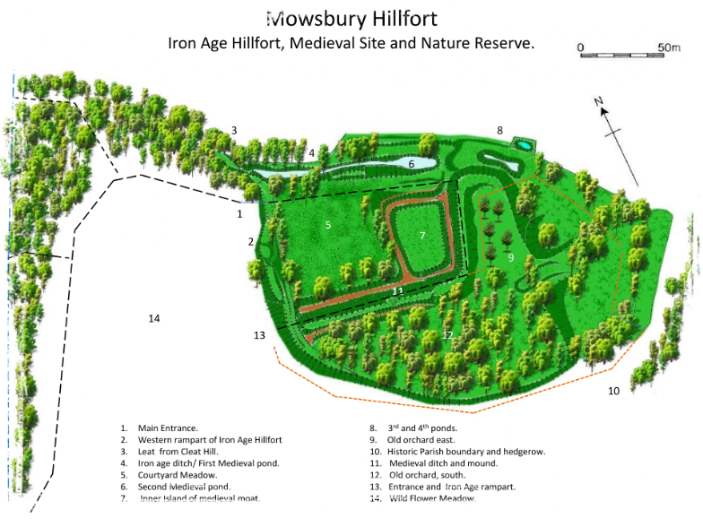
Archaeological trenching in 1971-1972 confirmed the presence of a single ditch encircling the tip of the spur, and measuring approx 4.3m wide and 2m deep; it had been completely in filled, incorporating material from the internal bank. The bank had been supported by a timber framework which had burnt down, leaving clear impressions of the timbers in the semi-fired clay of the bank; a fragment of human skull was found in association with the destruction. Traces of a possible hut circle were also found in the form of a circle of cobbles. The complete outline of the perimeter forms a roughly oval plan measuring approx 290m by 200m. Pottery fragments show that the hillfort was again occupied in the later Iron Age and into the Roman period, probably as a small farmstead. The next lasting mark made on the landscape is in the medieval period when a rectangular moated site, with two 'islands', an inner and an outer one, was developed. A wooden bridge would have allowed people to cross from the outer to the inner island. Parts of the moat may have reused the ditch of the original hillfort as part of the defensive structure and part was also adapted as a pair of fishponds for raising fish as a food source. The moat was filled with water, fed by a leat stream ( an artificial watercourse or aqueduct dug into the ground).
The medieval site has been identified with the manor of Morinsbury mentioned in various documents before 1465. Ralf Morrin was the land owner at the time and "Bury" being an old English word for castle or fortification. The name may have been retained as "Morsebury" a 16th century field name, which included the area of earthworks and presumably devolved to the present name of Mowsbury. Three small brickworks and kilns were active in the area around Cleat Hill in the late 19th century, some excervational workings can be noticed in and around the pond in the golf clubs car park, so this could explain some of the clay and brick debris found on site. During the 1880's Two rifle ranges, Cleathill and the Old rifle range were located where the golf club is today. The Hillfort is a listed English Heritage ancient monument, nature site and also has been awarded Higher Level Stewardship from Natural England. Mowsbury Hill Meadow is managed as a wild flower meadow.Archaeological trenching in 1971-1972 confirmed the presence of a single ditch encircling the tip of the spur, and measuring approx 4.3m wide and 2m deep; it had been completely in filled, incorporating material from the internal bank. The bank had been supported by a timber framework which had burnt down, leaving clear impressions of the timbers in the semi-fired clay of the bank; a fragment of human skull was found in association with the destruction. Traces of a possible hut circle were also found in the form of a circle of cobbles. The complete outline of the perimeter forms a roughly oval plan measuring approx 290m by 200m. Pottery fragments show that the hillfort was again occupied in the later Iron Age and into the Roman period, probably as a small farmstead. The next lasting mark made on the landscape is in the medieval period when a rectangular moated site, with two 'islands', an inner and an outer one, was developed. A wooden bridge would have allowed people to cross from the outer to the inner island. Parts of the moat may have reused the ditch of the original hillfort as part of the defensive structure and part was also adapted as a pair of fishponds for raising fish as a food source. The moat was filled with water, fed by a leat stream ( an artificial watercourse or aqueduct dug into the ground).
The meadow to the north of the hillfort has been used for clay and brick manufacturing, turf cutting as well as agriculture over the years but now Mowsbury Hill Meadow is managed as a wild flower meadow.
It has been suggested that the Courtyard Meadow was used as a garden during the medieval period but has been mentioned in some documents as a milking yard. Today common spotted orchids and other wild flowers flourish here
Running parallel and to the North of the Courtyard meadow the Iron Age ditches were converted in the medieval period into a series of ponds for the breeding of fish and used as a food source. The moated Island adjacent to the ponds was also a medieval addition to the site.
The Inner Island was cleared by the friends Group in 2012. It is the possible recorded site of the Manor of Morinsbury built in medieval times by Ralf Morin. A 'L' shaped trench was discovered, this is thought to be a robbers ditch ( Brick or stone removed or robbed for other purposes) but could be a drainage ditch or alike for the manor house.The present name 'Mowsbury' probably evolved from Morinsbury and Mossbury.
Two orchards were planted in the 1920's and extended in the 1970's, apple, pear, service and meddler with plum and sloes on the perimeter of each area. In 2012 a restoration and maintenance plan begun to save as many of the mature trees as possible and a number of new trees were planted to replace those that had been lost over recent years.